
GRAN FONDO Maryland SOCIAL RIDE
TIME: 1:00PM
LOCATION: Monocacy Brewing Company
(1781 N. Market St. Frederick, MD 21701)
DURATION: 90 Minutes
A fun shake out ride with just enough climbing to wake you up, but not too much to hurt you for the big day on Sunday. This is a social ride, so we’ll keep it at 2w/kg! Come out and get to know some of the Fondo Series staff and your fellow riders. Here’s the route: https://ridewithgps.com/routes/37450360

GRAN FONDO Maryland RIDER ROADBOOK
The 2021 Gran Fondo Maryland Roadbook is available as a PDF download. The information is also available in the Gran Fondo Maryland App, powered by Ride with GPS. In both you will find:
Packet Pickup times and locations
Parking information
Course details
Elevation profiles
Timed segment details
Turn-by-turn navigation (app only)


SURPRISINGLY CHALLENGING AND FUN
You may not associate Maryland with climbs, but Gran Fondo Maryland has one of the highest ratios of elevation gain per mile of any Gran Fondo National Series event. But don’t worry, the perfect pavement and cooler early fall temperatures make this one of our most popular events.

SHORT DRIVE FROM DC OR BALTIMORE
Frederick, MD is a very unique town and a fantastic place to bring the family. The Gran and Medio courses also pass by Camp David, the longtime country retreat for United States Presidents. The smooth, contoured road surfaces and quiet country environment lead us to believe Frederick County could be the best cycling destination in North America.

CELEBRATION OF SUMMER FITNESS
With proximity to huge cycling communities in Washington and Baltimore, and an early fall spot on the calendar, Gran Fondo Maryland is where cyclists go to celebrate their summer fitness before the cold weather comes. Some ride hard, and others just cruise, but everyone wants to get back to Frederick to enjoy the port-ride party.

SAFETY AND SUPPORT
With lots of turns that could lead you astray, you’ll appreciate the carefully marked and marshaled course, and you can ride with confidence due to support from law enforcement, safety motos, mechanic and sag vehicles, staffed feed stations, and indoor bathrooms along with hot showers await you at the finishline.

PRICES AND DATES
| PRICE PERIOD | GRAN | MEDIO | PICCOLO |
|---|---|---|---|
| Until January 10, 2021 | $120 | $100 | $65 |
| Jan 11 - August 20, 2021 | $130 | $110 | $75 |
| August 21 - September 9, 2021 | $140 | $120 | $85 |
| September 10 - September 15, 2021 | >$160 | $140 | $105 | September 16 - On-site | $175 | $155 | $120 |

COURSE MAPS & TIMED SEGMENTS
DOWNLOADABLE COURSE MAPS
The routes will be very well marked, but we encourage you to get the RideWithGPS App and load the route to your smart phone or GPS. Use this RSVP LINK to access premium RideWithGPS features and get turn by turn navigation for free.
TIMED SEGMENT MAPS AND PROFILES

Time Sections: (THE COMPETITION) – This is not a start-to-finish race. Your overall time from start to finish does not matter for this competition. Only the timed segments count. Your overall, age group, and gender rankings are determined by your combined time for all timed segments on the route you choose. View Complete Rules and FAQ.

ABOUT THE COURSE
Gran Route will gain over 10,000 feet of elevation through several different state parks, municipal forests, protected watersheds, and the Catoctin Mountain National Park. After exploring this incredible region, riders will return back into historic downtown Fredrick and be welcome to well deserved festivities at the finish line, complete with great food, beverage, and more fun.
Riders will travel northwest out of the city of Frederick before entering the Frederick Municipal Forest where the first timed section will gain over 1270 feet in a 5.6 mile race segment. At the top riders will be able to relax and enjoy the cool mountain forest as the course plummets over the west side of the mountain range.
The second timed section ascends the southern approach to Harp Hill for a punchy up-down-up-down-up lasting for a brief 1.4 miles and 279 feet of vertical gain. For the next 25 miles and 2500 feet of cumulative gain, the route then follows a mix of small and obscure backroads heading north towards the decommissioned military base of Fort Ritchie.
Gran route will gain over 10,000 feet of elevation through several different state parks, municipal forests, protected watersheds, and the Catoctin Mountain National Park. After exploring this incredible region, riders will return back into historic downtown Fredrick and be welcome to well deserved festivities at the finish line, complete with great food, beverage, and more fun.
Riders will travel northwest out of the city of Frederick before entering the Frederick Municipal Forest where the first timed section will gain over 1270 feet in a 5.6 mile race segment. At the top riders will be able to relax and enjoy the cool mountain forest as the course plummets over the west side of the mountain range.
The second timed section ascends the southern approach to Harp Hill for a punchy up-down-up-down-up lasting for a brief 1.4 miles and 279 feet of vertical gain. For the next 25 miles and 2500 feet of cumulative gain, the route then follows a mix of small and obscure backroads heading north towards the decommissioned military base of Fort Ritchie.
Time Section #3 is a more dynamic segment and certainly cannot be called a timed climb. Section #3 will require riders to use caution and technical skill with several 90° turns including an old bridge crossing and tarp & chip road surface. The section starts on a wide downhill roadway where for the first 4.9 miles riders lose 500 feet of elevation before hitting the last 1k and 300 vertical feet to the finish of section #3 on top of Hornets Nest Road. Time segment #3 known as The Gully of Darius is a total of 5.5 miles -574 /+386 feet. From here the route heads south and works its way back exploring nooks and crannies in the Catoctin Mountain Range and travels through Catoctin Mountain National Park for 22 miles and +2250 feet of untimed pedaling. Past riders will be able to take special appreciation as they descend Park Central Road, which was used in the opposite direct as race section #2 in past years.
As Gran route riders approach mile 71 they need to take in a deep breath, shake out their legs and prepare for the hardest segment of the day, (this segment also counts as a time segment for Medio Route riders). Section #4 is 11.4 miles +1203 feet and will test every rider’s ability! The segment starts by gaining 784 feet over the first 4.6 miles and then continues for a challenging and undulating 6.8 miles on top of the mountain ridge on Gambrill Park Road through Frederick Watershed and into Gambrill State Park. After completing time section #4, riders will have over 1000 feet of elevation on their side as they drop off the mountain range and into the valley towards the finish, but completing the route in not over, there are still some hills that are sure to make riders know they are still alive. Riders will return back into historic downtown Fredrick and be welcome to well deserved festivities at the finish line, complete with great food, beverage, and more fun.

ITINERARY
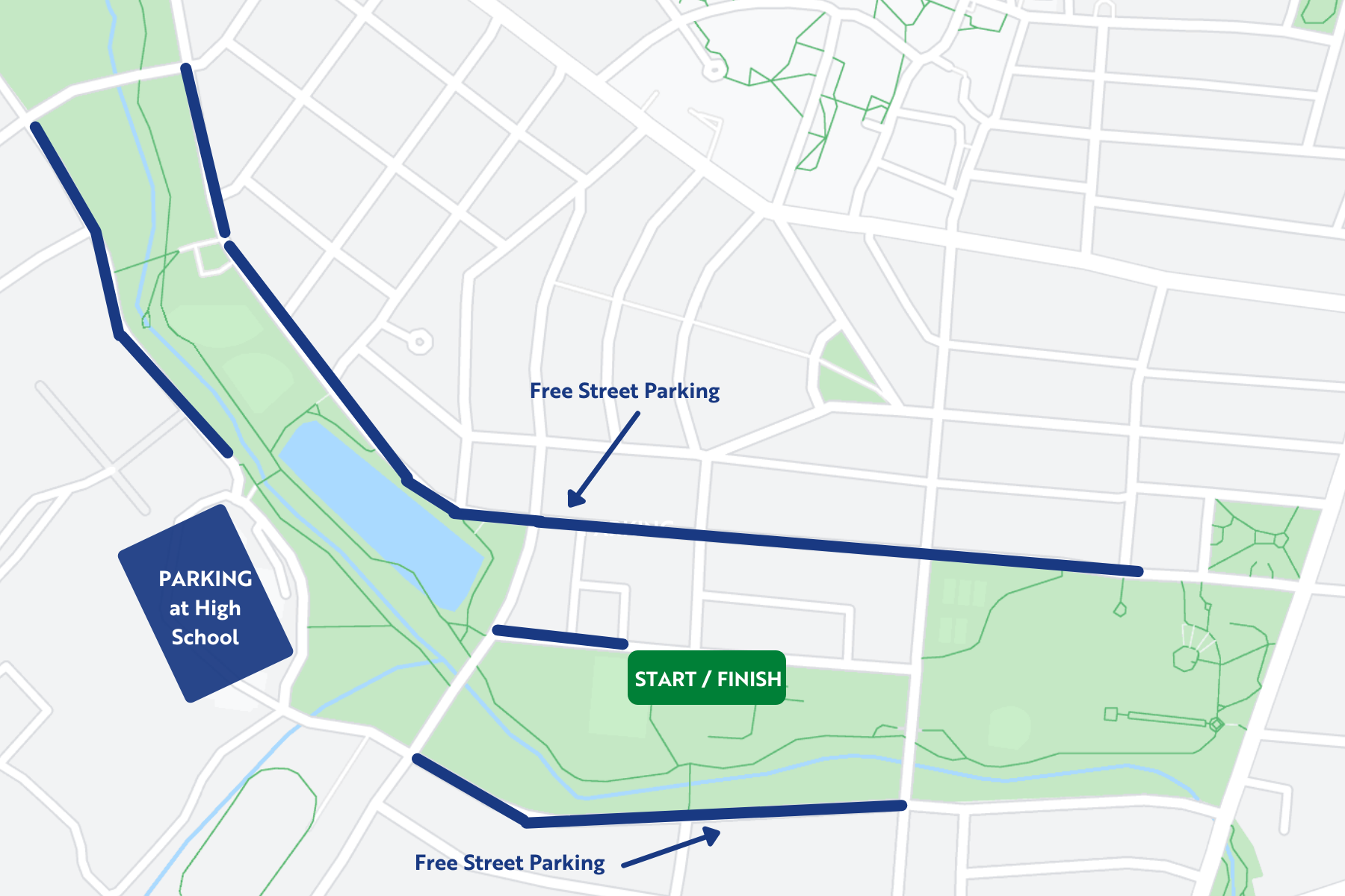
PARKING MAP
Please follow direction and park responsibly in designated parking spaces. Most on street parking near Baker Park is unmetered, but we encourage you to ensure it’s not a “resident only” location. There is also parking at the high school.
Do not park in regulated parking spots, you will get fined.

Rules
You Must Obey Traffic Laws. This is not a closed course. That means stop at lights and stop signs. Think Safety First.
Do not cause an accident!!!
Be respectful of others on the road!
NEVER CROSS THE CENTER-LINE OF THE ROAD!!!
During all race sections you have the right of way. When you are outside of race sections you do not have the right of way. You will not be racing through any intersections; this means when you come to a sign or signal you should slow down, stop, and be safe.
As you approach the time sections you must travel through the designated area (in your lane of traffic!) so that your chip can be properly read and recorded. The times for your timed sections will be compiled for your review at the finish. 100 mile = 4 timed sections; 55 mile = 2 timed sections; 20 mile = 1 timed section. You can view all the details for timed section on the above map links, click the map icons for details.
Timed sections are open for specific durations. In order to be timed and eligible for awards you must maintain a progression speed between 23mph and 10mph. NOTE: this is progression speed not average speed, progression speed includes all stopped time. Below is a list stating the times sections are open